File:1867 Mitchell Map of New York City, New York - Geographicus - NewYorkCity-mitchell-1870.jpg
Jump to navigation
Jump to search

Size of this preview: 800 × 527 pixels. Other resolutions: 320 × 211 pixels | 640 × 421 pixels | 1,024 × 674 pixels | 1,280 × 842 pixels | 2,560 × 1,685 pixels | 5,000 × 3,291 pixels.
Original file (5,000 × 3,291 pixels, file size: 5.13 MB, MIME type: image/jpeg)
Captions
Captions
Add a one-line explanation of what this file represents
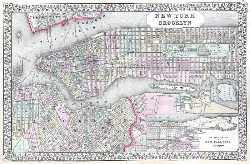
| Samuel Augustus Mitchell: New York and Brooklyn.
( |
||||||||||||||||||||
|---|---|---|---|---|---|---|---|---|---|---|---|---|---|---|---|---|---|---|---|---|
| Artist |
|
|||||||||||||||||||
| Title |
New York and Brooklyn. |
|||||||||||||||||||
| Description |
English: This beautiful hand colored map is a lithographic engraving of New York City, dating to 1867, by the legendary American map publisher S.A. Mitchell, the younger. Includes in inset map of Upper Manhattan and parts of Queens. Superb detail at the street level including the indication of individual buildings. Shows the various ferry routes between New York and Jersey City, as well as between Manhattan and Brooklyn. Central Park shown in its completed state. This is the first of the Mitchell series to depict Manhattan in full and on the horizontal. Dated and copyrighted “ Entered according to Act of Congress in the year 1867 by S. Agustus Mitchell in the Clerks Office of the District Court for the Eastern District of Pennsylvania. |
|||||||||||||||||||
| Date | 1870 (dated) | |||||||||||||||||||
| Dimensions | height: 14 in (35.5 cm); width: 21 in (53.3 cm) | |||||||||||||||||||
| Accession number |
Geographicus link: NewYorkCity-mitchell-1870 |
|||||||||||||||||||
| Source/Photographer |
Mitchell Jr., S. A., Mitchell's new general atlas, containing maps of the various countries of the World, plans of cities, etc, 1867.
|
|||||||||||||||||||
| Permission (Reusing this file) |
|
|||||||||||||||||||
File history
Click on a date/time to view the file as it appeared at that time.
| Date/Time | Thumbnail | Dimensions | User | Comment | |
|---|---|---|---|---|---|
| current | 06:51, 16 March 2011 | | 5,000 × 3,291 (5.13 MB) | BotMultichill (talk | contribs) | {{subst:User:Multichill/Geographicus |link=http://www.geographicus.com/P/AntiqueMap/NewYorkCity-mitchell-1870 |product_name=1867 Mitchell Map of New York City, New York |map_title=New York and Brooklyn. |description=This beautiful hand colored map is a li |
You cannot overwrite this file.
File usage on Commons
The following 2 pages use this file: