File:1864 Mitchell Map of the World on Hemisphere Projection - Geographicus - WorldHemi-mitchell-1864.jpg
Jump to navigation
Jump to search

Size of this preview: 701 × 599 pixels. Other resolutions: 281 × 240 pixels | 562 × 480 pixels | 899 × 768 pixels | 1,198 × 1,024 pixels | 2,396 × 2,048 pixels | 4,020 × 3,436 pixels.
Original file (4,020 × 3,436 pixels, file size: 3.06 MB, MIME type: image/jpeg)
Captions
Captions
Add a one-line explanation of what this file represents
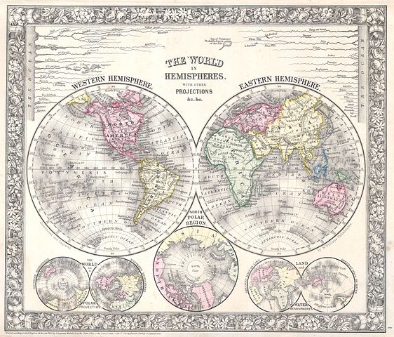
| Samuel Augustus Mitchell: The World in Hemispheres, with other Projections &c. &c.
( |
||||||||||||||||||||
|---|---|---|---|---|---|---|---|---|---|---|---|---|---|---|---|---|---|---|---|---|
| Artist |
|
|||||||||||||||||||
| Title |
The World in Hemispheres, with other Projections &c. &c. |
|||||||||||||||||||
| Description |
English: A beautiful example of S. A. Mitchell Jr.’s 1864 decorative double hemisphere map of the world. Depicts the world on a hemisphere projection. Upper part of the map shows the rivers in relative proximity. Lower half of the map features three additional world maps, a hemisphere map on a polar projection, a land and water hemisphere projection, and one of the northern polar regions. Prepared by S. A. Mitchell Jr. for inclusion as plate 1 in the 1864 issue of Mitchell’s New General Atlas . Dated and copyrighted, “Entered according to Act of Congress in the Year 1861 by S. Augustus Mitchell Jr. in the Clerk’s Office of the District Court of the U.S. for the Eastern District of Pennsylvania. |
|||||||||||||||||||
| Date | 1860 (dated) | |||||||||||||||||||
| Dimensions | height: 11 in (27.9 cm); width: 13 in (33 cm) | |||||||||||||||||||
| Accession number |
Geographicus link: WorldHemi-mitchell-1864 |
|||||||||||||||||||
| Source/Photographer |
Mitchell's New General Atlas, containing Maps of the Various Countries of the World, Plans of Cities, Etc., Embraced in Fifty-three Quarto Maps, forming a series of Eighty-Four Map and Plans, together with Valuable Statistical Tables. (1864 Edition)
|
|||||||||||||||||||
| Permission (Reusing this file) |
|
|||||||||||||||||||
File history
Click on a date/time to view the file as it appeared at that time.
| Date/Time | Thumbnail | Dimensions | User | Comment | |
|---|---|---|---|---|---|
| current | 13:05, 16 March 2011 | | 4,020 × 3,436 (3.06 MB) | BotMultichill (talk | contribs) | {{subst:User:Multichill/Geographicus |link=http://www.geographicus.com/P/AntiqueMap/WorldHemi-mitchell-1864 |product_name=1864 Mitchell Map of the World on Hemisphere Projection |map_title=The World in Hemispheres, with other Projections &c. &c. |descript |
You cannot overwrite this file.
File usage on Commons
The following page uses this file: