File:1860 Mitchell's Map of the West Indies, Mexico and Central America - Geographicus - WestIndies-m-1860.jpg
Jump to navigation
Jump to search

Size of this preview: 800 × 503 pixels. Other resolutions: 320 × 201 pixels | 640 × 402 pixels | 1,024 × 644 pixels | 1,280 × 805 pixels | 2,560 × 1,609 pixels | 3,500 × 2,200 pixels.
Original file (3,500 × 2,200 pixels, file size: 2.43 MB, MIME type: image/jpeg)
Captions
Captions
Add a one-line explanation of what this file represents
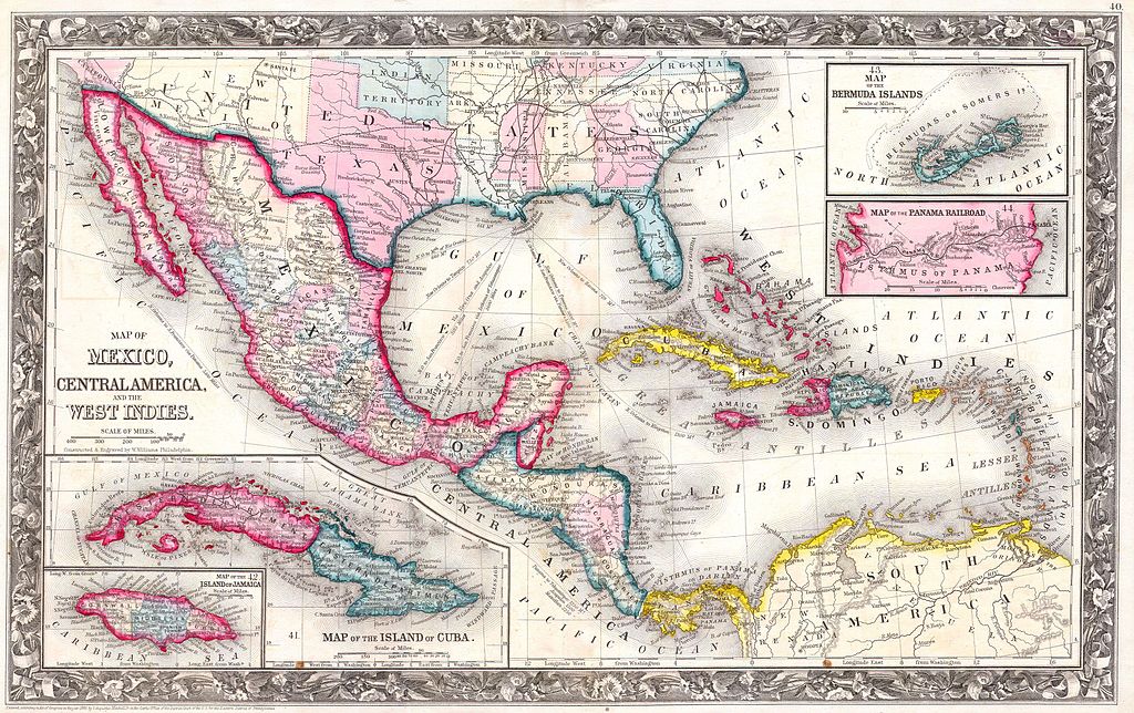
| Samuel Augustus Mitchell: A New Map of Mexico, Central America, and the West Indies. - Map of the Island of Cuba. - Map of the Bermuda Islands.
( |
||||||||||||||||||||
|---|---|---|---|---|---|---|---|---|---|---|---|---|---|---|---|---|---|---|---|---|
| Artist |
|
|||||||||||||||||||
| Title |
A New Map of Mexico, Central America, and the West Indies. - Map of the Island of Cuba. - Map of the Bermuda Islands. |
|||||||||||||||||||
| Description |
English: A fine example of Mitchell’s 1864 map of Mexico, Central America, and the West Indies. Depicts the region in considerable detail with notations regarding states, rail lines, shipping routes, and geographical features. Feature four inset maps. The two maps in the lower left quadrant depict the Island of Jamaica and the Island of Cuba. The two maps in the upper right quadrant feature the Bermuda Islands and the Isthmus of Panama (Panama Railroad). It is interesting to note that this map was not updated from the original 1860 issue to reflect the partitioning of New Mexico and Arizona in 1864. Mitchell may have used the left over printings of the 1860 issue of this map to populate his atlases until the mid 1860s when he finally updated the plate. One of the most attractive American atlas maps of the West Indies to appear in the mid 19th century. Features the floral border typical of Mitchell maps from the 1860-65 period. Prepared by W. Williams for inclusion as map nos. 48, 49, 50, 51 and 52 in the 1864 issue of Mitchell’s New General Atlas . Dated and copyrighted, “Entered according to Act of Congress in the Year 1860 by S. A. Mitchell Jr. in the Clerk’s Office of the District Court of the U.S. for the Eastern District of Pennsylvania. |
|||||||||||||||||||
| Date | 1860 | |||||||||||||||||||
| Dimensions | height: 13.5 in (34.2 cm); width: 22 in (55.8 cm) | |||||||||||||||||||
| Accession number |
Geographicus link: WestIndies-m-1860 |
|||||||||||||||||||
| Source/Photographer |
Mitchell's New General Atlas, containing Maps of the Various Countries of the World, Plans of Cities, Etc., Embraced in Fifty-three Quarto Maps, forming a series of Eighty-Four Map and Plans, together with Valuable Statistical Tables. (1864 Edition)
|
|||||||||||||||||||
| Permission (Reusing this file) |
|
|||||||||||||||||||
File history
Click on a date/time to view the file as it appeared at that time.
| Date/Time | Thumbnail | Dimensions | User | Comment | |
|---|---|---|---|---|---|
| current | 01:20, 25 March 2011 | | 3,500 × 2,200 (2.43 MB) | BotMultichillT (talk | contribs) | {{subst:User:Multichill/Geographicus |link=http://www.geographicus.com/P/AntiqueMap/WestIndies-m-1860 |product_name=1860 Mitchell's Map of the West Indies, Mexico and Central America |map_title=A New Map of Mexico, Central America, and the West Indies. - |
You cannot overwrite this file.
File usage on Commons
The following page uses this file: