File:1846 Burroughs - Mitchell Map of Maryland ^ Delaware w- Baltimore Inset - Geographicus - MD-burroughs-1846.jpg

Original file (3,000 × 2,354 pixels, file size: 1.92 MB, MIME type: image/jpeg)
Captions
Captions
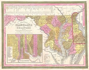
| A New Map of Maryland and Delaware with their Canals, Roads & Distances. | ||||||
|---|---|---|---|---|---|---|
| Artist | ||||||
| Title |
A New Map of Maryland and Delaware with their Canals, Roads & Distances. |
|||||
| Description |
English: This scarce hand colored map is a lithographic engraving of Maryland and Delaware, dating to 1846 by the legendary American Mapmaker S.A. Mitchell, the elder. Includes a detailed inset map of Baltimore. This is a rare transitional map produced by the mysterious engraver H. N. Burroughs, whose work for the Mitchell firm appears in 1846 between that of H.S. Tanner and Mitchell himself. Ristow notes, Nothing is known about Burroughs, but he was undoubtedly an employee or associate of Mitchell. His fine and detailed work appears only in the hard to find 1846 edition of the Mitchell’s Atlas. Dated and copyrighted 1846. |
|||||
| Date | 1846 | |||||
| Dimensions | height: 11.5 in (29.2 cm); width: 14.5 in (36.8 cm) | |||||
| Accession number |
Geographicus link: MD-burroughs-1846 |
|||||
| Source/Photographer |
|
|||||
| Permission (Reusing this file) |
|
|||||
File history
Click on a date/time to view the file as it appeared at that time.
| Date/Time | Thumbnail | Dimensions | User | Comment | |
|---|---|---|---|---|---|
| current | 19:41, 24 March 2011 | | 3,000 × 2,354 (1.92 MB) | BotMultichillT (talk | contribs) | {{subst:User:Multichill/Geographicus |link=http://www.geographicus.com/P/AntiqueMap/MD-burroughs-1846 |product_name=1846 Burroughs / Mitchell Map of Maryland & Delaware w/ Baltimore Inset |map_title=A New Map of Maryland and Delaware with their Canals, Ro |
You cannot overwrite this file.
File usage on Commons
The following page uses this file: