File:1832 S.D.U.K. City Plan or Map of Pompeii, Italy - Geographicus - Pompeii-SDUK-1832.jpg
Original file (3,500 × 2,762 pixels, file size: 2.63 MB, MIME type: image/jpeg)
Captions
Captions
| Title |
Pompeii. |
|||||||||||||||||||
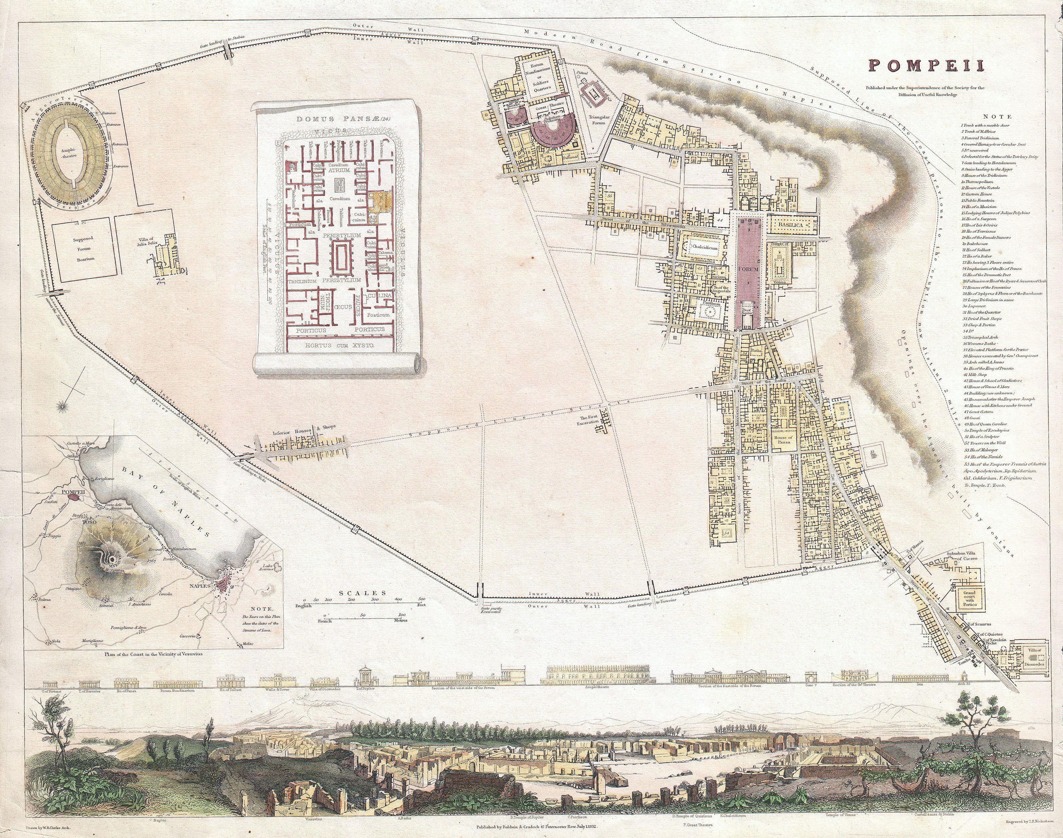
| Description |
English: A beautiful example of the 1832 S.D.U.K. map of Pompeii, Italy. Pompeii was destroyed by the eruption of the volcano Vesuvius, in A.D. 79 and remained buried under ash until its rediscovery in 1748. Though excavations had been in process for nearly 60 years when this map was printed, very little of this ancient Roman city had been unearthed. The excavated portions of Pompeii, confined to the right hand quadrants of the map, drew the attention of the world as more and more of the fantastically preserved pleasure city was unearthed. For Englishmen and women visiting Italy as part of the “Grand Tour”, Pompeii was a must see. The discoveries here, reported by travelers, may have been partially responsible for the classical revival of the mid 19th century. Map shows the walled city of Pompeii with numerous important buildings labeled including the Amphitheater, the Villa of Julia Felix, the Forum, the Grand Theater, the Temple of Hercules, the Basilica, and the Grand Court, to name but a few. An inset map in the lower left hand quadrant shows Vesuvius and vicinity. Another inset set in the “unexcavated” portions of Pompeii, shows the layout of a typical Pompeii villa. A decorative view along the bottom of the map shows the cities as it must have appeared to 19th century travelers. Above this view are artistic renderings of important Pompeii Buildings. Drawn by W. B. Clarke and engraved by T. E. Nicholson for publication in the 1844 Baldwin and Craddock’s issue of the Society for the Diffusion of Useful Knowledge Atlas . |
|||||||||||||||||||
| Date | (dated) | |||||||||||||||||||
| Source |
Baldwin & Craddock, Maps of the Society for the Diffusion of Useful Knowledge. Vol. 1. London: Chapman and Hall, 186, Strand, 1844.
|
|||||||||||||||||||
| Creator |
|
|||||||||||||||||||
| Permission (Reusing this file) |
|
|||||||||||||||||||
| Geotemporal data | ||||||||||||||||||||
| Bounding box |
|
|||||||||||||||||||
| Georeferencing | ||||||||||||||||||||
| Archival data | ||||||||||||||||||||
| Accession number |
Geographicus link: Pompeii-SDUK-1832 |
|||||||||||||||||||
| Dimensions | height: 12.5 in (31.7 cm); width: 15.5 in (39.3 cm) | |||||||||||||||||||
| Other versions |
|
|||||||||||||||||||

- Error in {{Map}} template: unknown parameter "artist".
File history
Click on a date/time to view the file as it appeared at that time.
| Date/Time | Thumbnail | Dimensions | User | Comment | |
|---|---|---|---|---|---|
| current | 13:15, 22 March 2011 | | 3,500 × 2,762 (2.63 MB) | BotMultichillT (talk | contribs) | {{subst:User:Multichill/Geographicus |link=http://www.geographicus.com/P/AntiqueMap/Pompeii-SDUK-1832 |product_name=1832 S.D.U.K. City Plan or Map of Pompeii, Italy |map_title=Pompeii. |description=A beautiful example of the 1832 S.D.U.K. map of Pompeii, |
You cannot overwrite this file.
File usage on Commons
The following page uses this file:
File usage on other wikis
The following other wikis use this file:
- Usage on it.wikipedia.org
- Usage on ru.wikipedia.org