File:1796 Benjamin Taylor Manuscript Survey Map of Tribeca, New York and Indenture - Geographicus - Tribeca-taylor-1796.jpg
Jump to navigation
Jump to search

Size of this preview: 800 × 402 pixels. Other resolutions: 320 × 161 pixels | 640 × 322 pixels | 1,024 × 515 pixels | 1,280 × 643 pixels | 3,855 × 1,938 pixels.
Original file (3,855 × 1,938 pixels, file size: 592 KB, MIME type: image/jpeg)
Captions
Captions
Add a one-line explanation of what this file represents
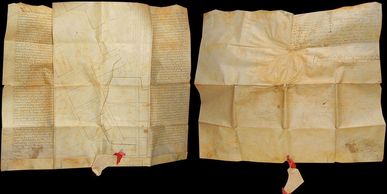
| A Map shewing the arrangemnt agreed to between the Corporation of Trinity Church, and the Proprietors of the Estate late Ireland's, with regard to Streets, &c. &c. | ||||||
|---|---|---|---|---|---|---|
| Artist | ||||||
| Title |
A Map shewing the arrangemnt agreed to between the Corporation of Trinity Church, and the Proprietors of the Estate late Ireland's, with regard to Streets, &c. &c. |
|||||
| Description |
English: This is a rare historic 1796 indenture and associated manuscript survey map documenting the transfer of certain lands in the Tribeca district of Manhattan from the Trinity Church Corporation to the City of New York. The indenture agreement bears the signatures of several important New York figures including Thomas Cooper (a friend of Jefferson, Franklin and Washington), Richard Harrison (important official of Trinity Church), John Charlton, and Robert Benson. Original paper and wax seal attached, though broken. The interesting attached manuscript map, also on vellum, was drawn by the important New York surveyor Benjamin Taylor. Taylor was a contemporary of Goerck and is responsible numerous important 18th century surveys of various parts of this city. The map in question covers modern day Tribeca from Greenwich Street to Church Street (Chapel Street) and from Reade Street to Moore Street. Names numerous early streets including Harrison, Jay, Thomas, Catherine, Barley, Provost and Duane Street. Also notes the Location of Varick Street, which at the time has been built but not named. Shows the locations of several early boundaries and land lots which are mentioned and exchanged in the associate indenture contract. It would be difficult to come by an earlier or more important piece of original New York City survey work. Both recto and verso of document are show above. |
|||||
| Date | 1796 (dated) | |||||
| Dimensions | height: 21 in (53.3 cm); width: 26 in (66 cm) | |||||
| Accession number |
Geographicus link: Tribeca-taylor-1796 |
|||||
| Source/Photographer |
|
|||||
| Permission (Reusing this file) |
|
|||||
File history
Click on a date/time to view the file as it appeared at that time.
| Date/Time | Thumbnail | Dimensions | User | Comment | |
|---|---|---|---|---|---|
| current | 05:33, 23 March 2011 | | 3,855 × 1,938 (592 KB) | BotMultichillT (talk | contribs) | {{subst:User:Multichill/Geographicus |link=http://www.geographicus.com/P/AntiqueMap/Tribeca-taylor-1796 |product_name=1796 Benjamin Taylor Manuscript Survey Map of Tribeca, New York and Indenture |map_title=A Map shewing the arrangemnt agreed to between t |
You cannot overwrite this file.
File usage on Commons
The following page uses this file: