File:1657 Jansson Map of France or Gaul in Antiquity - Geographicus - Galliae-jansson-1657.jpg
Jump to navigation
Jump to search

Size of this preview: 743 × 600 pixels. Other resolutions: 297 × 240 pixels | 595 × 480 pixels | 952 × 768 pixels | 1,269 × 1,024 pixels | 2,537 × 2,048 pixels | 3,500 × 2,825 pixels.
Original file (3,500 × 2,825 pixels, file size: 3.39 MB, MIME type: image/jpeg)
Captions
Captions
Add a one-line explanation of what this file represents
Summary[edit]
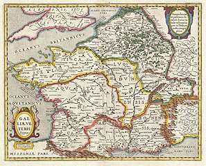
| Jan Janssonius: Diagram of Old Gaul [Galliae Veteris Typus]
( |
||||||||||||||||||||||||||
|---|---|---|---|---|---|---|---|---|---|---|---|---|---|---|---|---|---|---|---|---|---|---|---|---|---|---|
| Artist |
|
|||||||||||||||||||||||||
| Title |
Diagram of Old Gaul [Galliae Veteris Typus] |
|||||||||||||||||||||||||
| Description |
English: This is a remarkable example of Jan Jansson's 1657 mapping of France or Gaul in antiquity. Cartographically this map exhibits heavy influence from a very similar map of the same name published by A. Ortelius in his 1597 Parergon . Based on Greek and Roman sources including Pliny, Strabo, Virgil, Ceasar, and others. A decorative title cartouche depicting curious winged women with exceptionally long necks (harpies?) appears in the lower left quadrant. This remarkable map was published in volume six, the Orbis Antiquus , of Jan Jansson's Novus Atlas .
Français : Ceci est un exemple remarquable de cartographie de la France ou Gaule dans l'Antiquité par Jan Jansson en 1657. Cartographiquement, cette carte présente une forte influence sur une carte très similaire et du même nom publiée par A. Ortelius dans son Parergon 1597. Elle est basée sur des sources grecques et romaines dont Pline, Strabon, Virgile, César, et d'autres. Une cartouche de titre décoratif représentant de curieuses femmes ailées avec le cou exceptionnellement long (harpies ?) apparaît dans le quadrant inférieur gauche. Cette carte remarquable a été publié en six volumes, l’Orbis Antiquus, de Jan Jansson Novus Atlas. |
|||||||||||||||||||||||||
| Date | 1657 (undated) | |||||||||||||||||||||||||
| Dimensions | height: 16 in (40.6 cm); width: 20 in (50.8 cm) | |||||||||||||||||||||||||
| Accession number |
Geographicus link: Galliae-jansson-1657 |
|||||||||||||||||||||||||
| Source/Photographer |
Jansson, J., Novus Atlas, Sive Theatrum Orbis Terrarum: In quo Orbis Antiquus, Seu Geographia Vetus, Sacra & Profana exhibetur, Volume 6, 1657.
|
|||||||||||||||||||||||||
| Permission (Reusing this file) |
|
|||||||||||||||||||||||||
File history
Click on a date/time to view the file as it appeared at that time.
| Date/Time | Thumbnail | Dimensions | User | Comment | |
|---|---|---|---|---|---|
| current | 21:03, 23 March 2011 | | 3,500 × 2,825 (3.39 MB) | BotMultichillT (talk | contribs) | {{subst:User:Multichill/Geographicus |link=http://www.geographicus.com/P/AntiqueMap/Galliae-jansson-1657 |product_name=1657 Jansson Map of France or Gaul in Antiquity |map_title=Galliae Veteris Typus. |description=This is a remarkable example of Jan Janss |
You cannot overwrite this file.
File usage on Commons
The following page uses this file:
File usage on other wikis
The following other wikis use this file:
- Usage on fr.wikipedia.org